
12 May 2023:
Surveyor Robert Hoddle is famous for laying out the original town grid of Melbourne in 1837, but he wasn’t very creative about it. So I’ve re-drawn his plan of Melbourne, with improvements, a speculative design of what might have been.
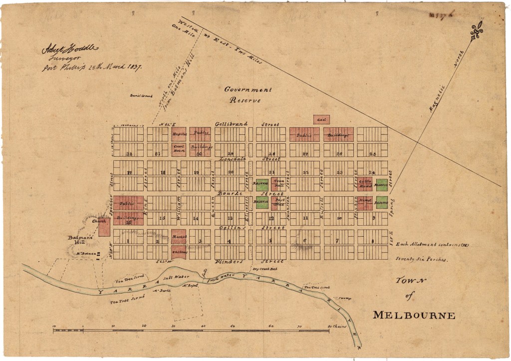
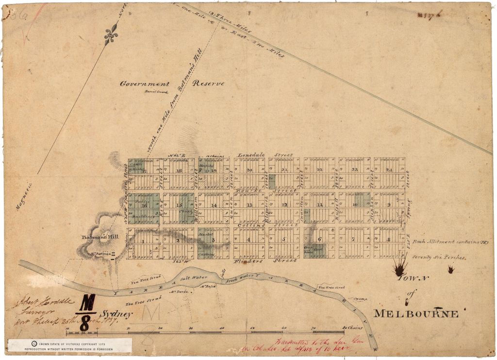
– I’ve drawn it up to Latrobe, which wasn’t actually surveyed until 1839 (which I called Gellibrand, because Governor Latrobe wasn’t around in 1837), and included the public building reserves from that layer extension.
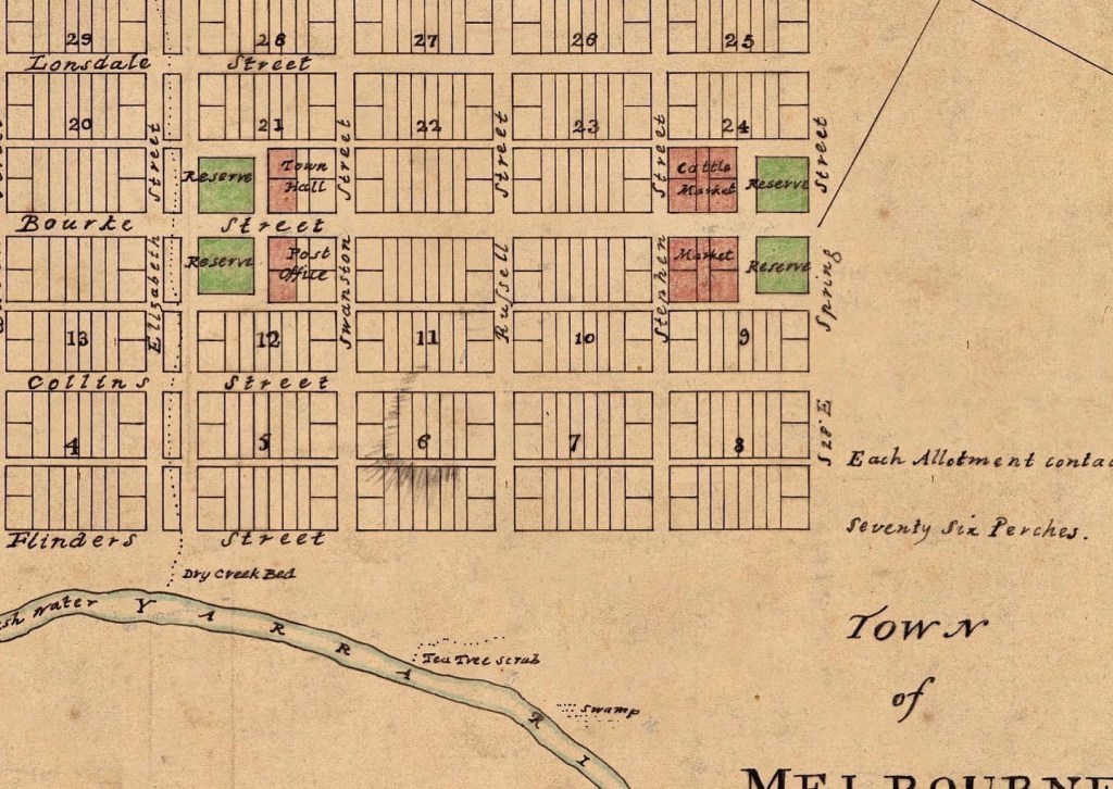
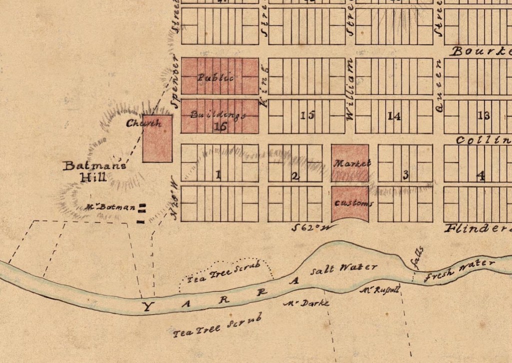
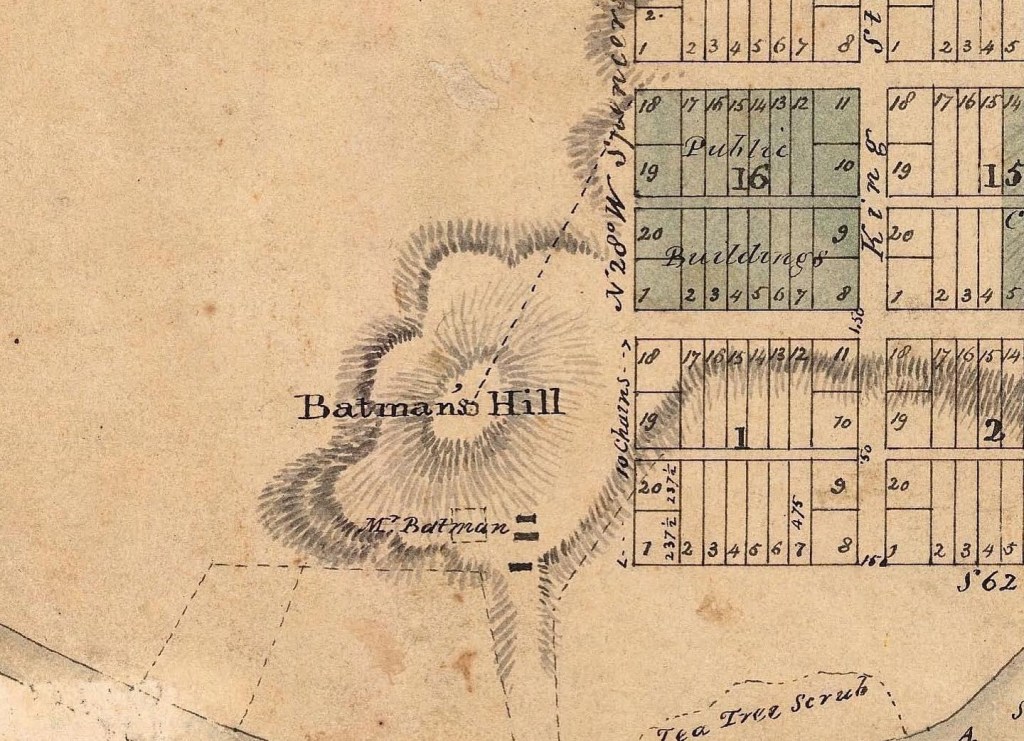
– I put the reserves in symmetrical arrangements, some fronting ‘town squares’, some on the axis of the streets. For instance I put the church on Batman’s hill on the axis of Collins, and the Gaol on the hill at the top of Russell.
– I made Elizabeth Street much wider to accommodate the fact that it was a water course,
– I made Bourke Street a bit wider too, as a cross axis. I’ve been influenced by knowing what came later, with the top of Bourke Street being an even more obvious location for Parliament House, and putting the Courthouse and Gaol close to where they ended up.
– I think the city would have evolved much the same way as it actually did, e.g. Collins Street as the most prestigious address, but exactly how it might it have looked at later dates is my next series of sketches!
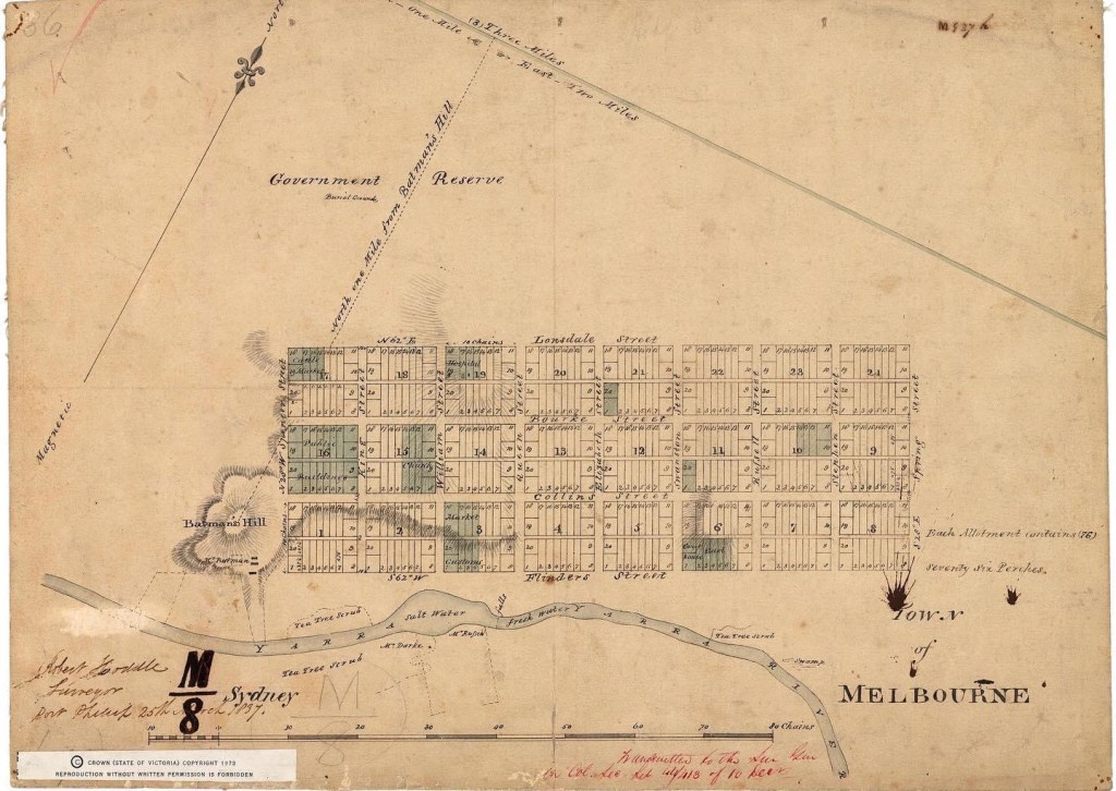
Hoddle plan explained :
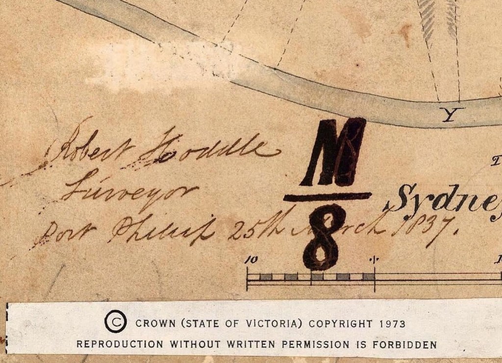
Our city’s founding document (sort of) – government surveyor Robert Hoddle’s 1837 survey of Melbourne’s first streets, held at @vic_archives, when the population was about 700 mostly Tasmanians and lots of sheep. Things to note : The streets are 99ft wide rather than then normal 66ft, because Hoddle preferred wider streets, but Governor Bourke, who came with Hoddle from Sydney, insisted on back lanes for rear access, which were only 33ft wide (but the lots were soon subdivided with properties facing the ‘lanes’); Bourke named the town after then British PM Lord Melbourne and the streets after various officials; it only went up to Lonsdale (up to Latrobe was 1839); it followed standard regulations which did not involve central squares or plazas, instead it was all about creating regular lots for sale (and the outside streets are only one sided); and did not take much notice of topography, though aligned along the river and avoided Batman’s Hill, but Elizabeth Street was a valley that was a terrible winter bog until big drains built. Also, it’s not very well centred, and the writing’s a bit wonky – especially his signature bottom left. Also an annotated plan to show what the various sites reserved for various purposes eventually became, and how the river lagoon and fresh water was the reason for locating the town right here.


Dear Rohan
Thanks for recording and sharing the history of Melbourne’s built environment.
I can recall my late father (Michael Cully, born in Melbourne, 1917) saying that Melbourne’s original architect had designed the city’s streets to accommodate the turning circle needed for horse drawn carriages. My father had memories of Bourke Street with horse and carts, before cars were common (he worked as a paper boy on Melbourne streets from the age of 5). Dad said the original architect had seen “all the trouble they had with narrow streets” in Britain/Europe, and designed Melbourne’s streets to avoid these problems. For example, some roads (?Royal Parade) were designed with parallel side roads to allow farmers to drive livestock to market (on foot) without clogging up the main road.
Dad said that the original design of wide streets extended well beyond the city. However, instead of implementing the architect’s original design, Dad said the authorities cut back (for example, at Sydney Road), which resulted in the traffic problems we have “today” (which was then around 1967 – 1972).
Thought you might be interested in Dad’s oral history.
Kind regards Ruth Cully
LikeLike
The sort of story that sounds good, but not particularly accurate! The standard width for streets was 66ft, wide enough for a horse and cart to turn, but Hoddle liked them wider, so the city streets are 99ft, and then outside the grid he went to 132 ft for a few main roads, but Sydney road and bridge road were done by others later, and went back to 66ft – they should have stuck to the wider roads !
LikeLike